

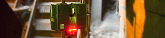
This is a very quick and accurate collection of detailed data of the actual implementation. 3D laser scanner spreding around itself a laser beam in a circular profiles and collects up to 1 million points / sec in the space around. These points are marked by XYZ coordinates, it is recorded reflection intensity of the scanned object and also its realistic color. These data can be displayed, analyzed or from these data can be created a 3D CAD model.
What benefits brings 3D laser scanning:
- It will come into being a comprehensive survey documents, which credibly represents reality with minimum deviations
- Very fast data collection and can be measured elements that are almost impossible to measure by other technologies./li>
- Very accurate measurements – Our scanners are reaching an accuracy 2 mm.
- Possibility to measure during operation
- Drops Number of remeasuring object will drop – reduces the potential economic costs and a project won’t be suspended.
- Project can be measured in the dark and in shielded spaces
- The results can be imported into your CAD systems
You have interest because…
- Are you missing technology documentation of device or object?
- Do you need to comprehensively determine the deformation of the object, or to perform a detailed analysis of the actual construction?
- Do you want to streamline the management of large complex at a distance?
- Do you like rendered animation of a cloud of points?
- Or do you want “only” record the actual condition of the building?
If your answer to any of these questions is “yes”, we can help you with that. Or if you have any complication that can be solved by using laser scanning, don’t hesitate to contact us.
Our services
Targeting of objects using laser scanning
We will target your desired area with all benefits that brings laser scanning. We own more scanners – we can work on multiple projects at the same time.
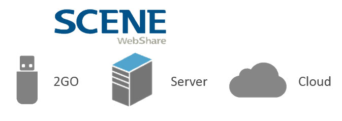
Processing of cloud of points and formation of a Webshare project
We will deliver to you cloud points in LAS, E57, PTX, POD …formats. We will prepare a scaned project to Webshare project that can be placed on a local PC, Server, or “in the cloud”. More info
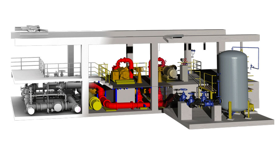
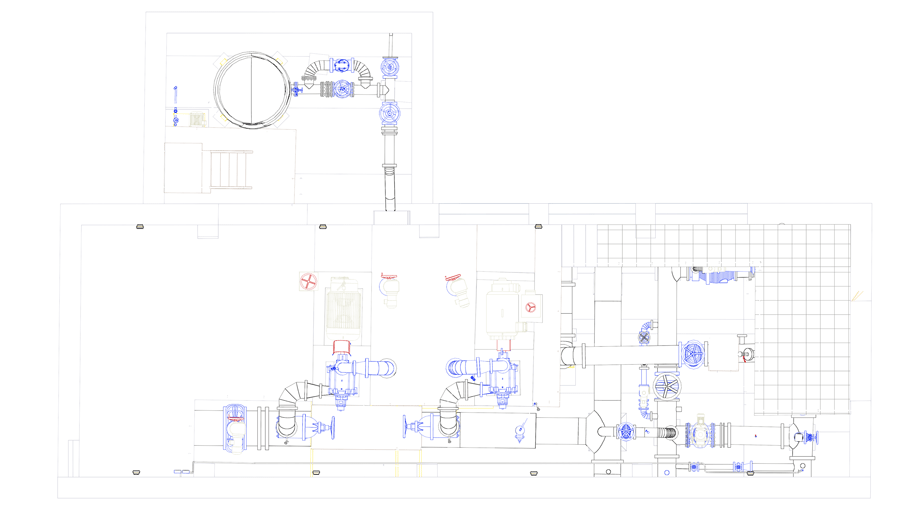
Delivery of a complex 3D model
From the scanned data we will produce a complex 3D model in formats: DWG, DGN, STEP, IGES… The model is exported even to 3D PDF for easy measurement for anybody. It is very useful for project work, documentation of actual construction or as data to information systems.
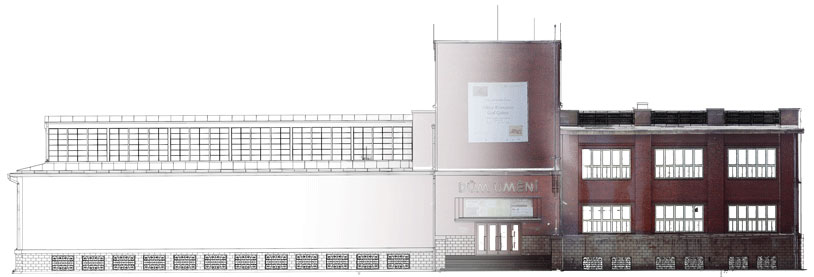
Targeting of building's facades
We will target any shape of facade, and if it is needed, we will supply photogrammetric measurement for better visual perception.
The creation of 2D vector and bitmap slices and views
From the perspective of the 3D model or cloud of points we will create 2D slice Option to tint a bitmap image
Evaluation of the deformation of the object
We will provide measurements of objects in stages and evaluation of the shift and transformation between the various stages.
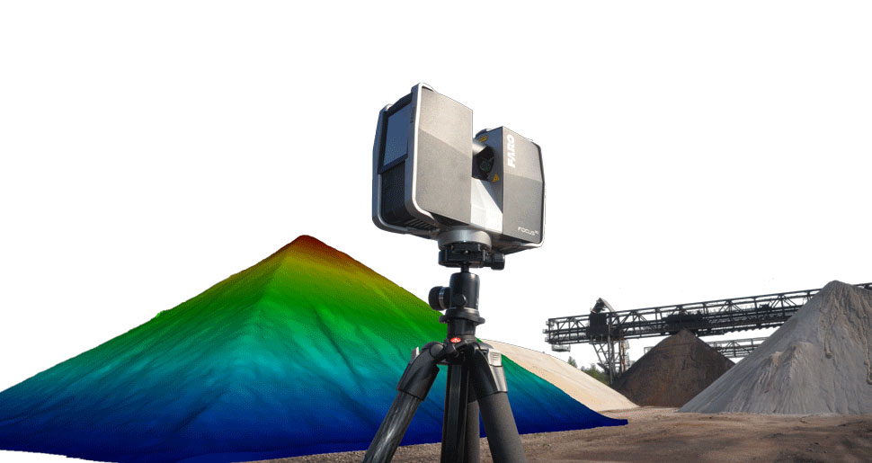
Calculation of volume capacity with an accuracy of up to 0.1%
We will determine the volume capacity of your stocks with a very high accuracy! The possibility of phased measurement
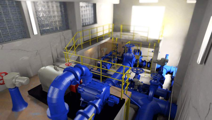
Rendered views
For 3D model are defined real materials and set the position of the lighting of the view and by this will originate a very powerful 3D visualization model
Animation at resolutions up to 4K
After the planned trajectory we will create a great animation of the scanned area from cloud of points, combined with the 3D model.
Fields of Use
- Mechanical Engineering and Metallurgical Industry
- Building construction
- Architecture and Conservation
- Chemical Industry
- Energy Industry
- Restoration
- Mapping of Underground
- Mining Industry
- Film Industry
- Forensic Engineering
- Road Construction
Fields of Application:
Projection activity
If you use all the benefits of 3D design in any CAD program and you don’t have measured data and the CAD model, do not hesitate to use our services.
If the location is away from your office you should certainly take advantage of the Webshare project benefits, that will greatly and clearly demonstrate the space of the project. In addition, you can easily share information with colleagues, which are located right in the space of the project by using hyperlinks.
Conceptual designs – Data from the laser scanning provides designers with a better understanding of existing conditions. Using image information, cloud of points animations or model from 3D printer is possible more clearly communicate with clients and explain them the aim of the proposal.
Under construction
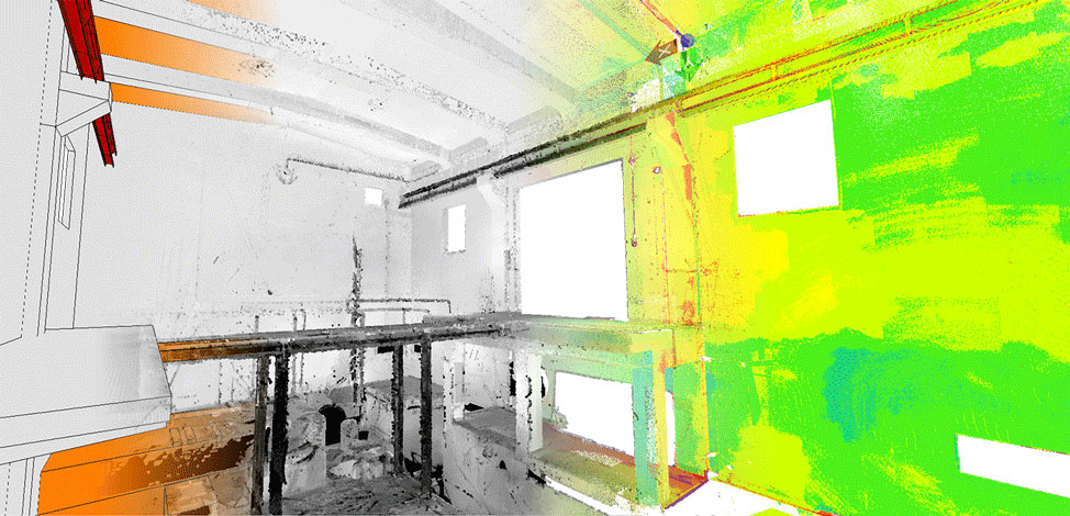
Laser scanning can be used during the construction phase to determine the geometrical parameters (flatness, verticality of walls, columns …), or also for a comprehensive analysis of deviations from the construction of the proposed project. Representation of deviations may take the form of a spatial cloud of points with a color characterizing the certain deviation, or drawing with hypsometrical representation of deviations.
If the construction is assessed comprehensively, it is possible from these data prepare the real targeting of construction. This documentation will after construction, save time and will provide a complete and accurate geometric information of the construction, despite its possible reconstruction. Data can be uploaded to Webshare Cloud and give to owner of the building an effective tool to manage the network.
Another use is economic character and it is a very precise determination of capacity volumes of excavations and reservoirs with accuracy up to 0.1% of the determined amount.
Engineering activities
Deformation analysis – objects tracking over time, which are often exposed to extreme temperatures, pressures and corrosive substances. 3D documentation and its subsequent analysis of the current status of the device is very suitable for the right decision of servicing operations.
Deformation monitoring – Suitable for regular monitoring of changes to objects, as well as a basis for devising of their protection.
Suitable for geometric survey during the high-voltage lining, finding of its sagging and analysis of firebreaks, determine the size of the buildings for demolition, and also to capture the current state of your devices…
Facility Management
Today’s standard, that every village has its own GIS. If you have a large area to manage, we can help you get it in one place. We will perform an inventory of elements, together with the placement in a space. The results can be viewed easily anywhere on a PC or tablet.
If you have insufficient surveying documents, or it is completely missing, we offer a comprehensive targeting of the area and execution of complex 3D model.
Cultural heritage and monument care
Non-invasive method for the measurements of the objects too fragile for direct contact.
Maintaining an accurate digital recording of archaeological sites and historic buildings with significant historic value. Laser scanning is an excellent tool for recording complex and hard to reach places that are difficult to capture by traditional surveying techniques.
Marketing and Entertainment
Visualization – Creating cloud of points rendered animations, 3D models that allow visitors a virtual tour of the monuments. It could be used also in the creation of promotional items, such as models from 3D printers.
LS can serve as a technology to obtain data for the newly emerging trends such as Microsoft products Hololens and Oculus Rift.
Data Collection
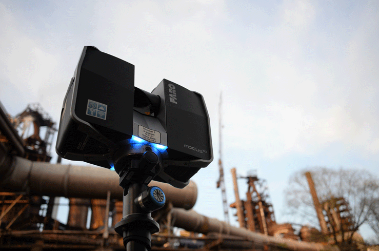
With the Scanner we target a complex geometry and structure of the area around the scanner up to a distance of 120 m and measuring speed up to 1 million points per second. Of course there is a scan from multiple positions so there wouldn’t be created dead spots. The scanner includes a safe Class 1 laser, therefore there isn’t any risk of eye damage.
Projects can be scanned at very high resolution. Usually, we use the detailed scanning of resolution 2 mm to 10 m. Since the density is defined by a size of the angle, its resolution is going to have 20 m spacing between points 4 mm.
Our technical equipment
- Faro Focus 3D 120
- Scanner Range: 120 meters
- Measuring speed: up to 976,000 points / second
- Laser Class: 3R
- The accuracy of the distance measurement < 2 mm
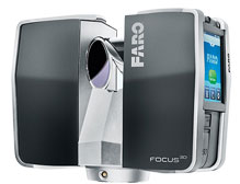
- Integrated Color Camera, Integrated sensors (compass, barometer, compensator)
- Control Scanner touchscreen or WiFi,(ability to control with smart phones or tablet via a web browser)
- Weight / dimensions: 5.2 kg / 240 x 200 x 100 mm
At this moment we have two scanners, that allows us a quick scanning of large project, or more efficiently to respond to multiple projects at the same time.
The processing of measurement
First, scanning positions are connected in a single project. Then the cloud of points is covered in true colors. Next step is cleanup of data from unwanted objects and control of the overall accuracy so it would meet the requirement of the customer. Furthermore, the project is georeferenced to the local system, S-JTSK or UTM. Then the cloud of points is formed with a uniform density of points in the whole project.
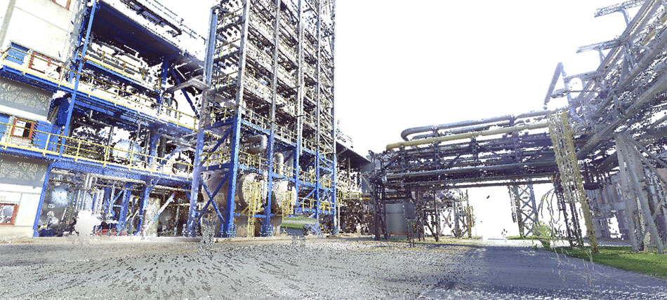
Cloud of points
It is the primary output of a laser scanning. Loud of points can be connected directly to the CAD software.
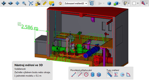
Webshare
This is a viewing of the scanned area in a web browser.The scanned area is displayed in panoramic image from each scanned position.It is possible to measure and subtract coordinates, write notes and share links of views and comments with other colleagues.Project data can be recorded locally on the PC, the business server, or they can be uploaded to cloud services.
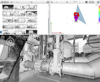
3D model


3D model is exported to the 3D PDF format, so that it could be viewed and used by each and every user, without special CAD software.
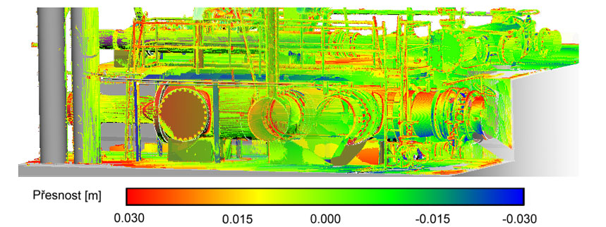
On one of our projects, we have determined the accuracy of vectorization. The final 3D model was compared with the cloud of points. By a color scale is shown the deviation.
3D model is exported to a large number of formats, so that customers would be able to use their existing CAD systems. The model is “alive”, therefore, it can be continuously used for work.